Unplanned flight into cloud rarely ends well. Setting aside the capabilities of your aeroplane and your own piloting skills, the shock is guaranteed to send stress levels through the roof. Combine it with nearby terrain that climbs faster than you can, plus a familiarity with your attitude indicator that dates back to your early PPL training, means your prospects of successfully recovering the situation are not high. That said, this mixed bag of incidents suggest all is not necessarily lost, while reinforcing the old adage that some forethought and little practice will go a long way to improving outcomes!
Accident 1
A Piper PA-28 departed Warnambool Airport for a return to Moorabbin Airport, Victoria. The flight crew were conducting a training flight under visual flight rules (VFR). There was an instructor, student pilot and a passenger on board. During the cruise, the weather deteriorated and the aircraft returned to Warrnambool.
During the initial stages of the return the visibility was good but as they got closer to Warrnambool the visibility reduced and they had to descend as the cloud base again began to lower. While approaching Warrnambool township, at approx 450ft agl, the instructor slowed the aircraft and extended two stages of flap. The visibility reduced significantly and the instructor, not wanting to descend further, made the decision to climb into cloud.
Following initial radio communication difficulties ATC responded to a call where the instructor advised they were in cloud and were requesting assistance. After clarifying the aircraft’s location and the pilot’s intentions, ATC assisted with information on the local weather, the lowest safe altitude and subsequently provided advice to keep the wings level, maintain a constant speed and to trust their instruments.
Initially the instructor maintained a shallow climb and a low angle of bank turn to remain within an area around Warrnambool known to be clear of obstacles. When they reached 3,000ft, they turned north to ensure they did not track over water. They advised that in an attempt to fix the apparent radio problems they also switched between the two radio units in the aircraft and exchanged headsets with the student pilot. They continued the climb to 4,500 ft.
ATC identified the aircraft on radar and issued the flight crew with a heading to Avalon Airport as the pilot of a helicopter in that area had reported operating clear of cloud. The flight then continued and landed normally at Moorabbin Airport
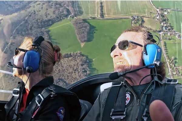
The instructor held a valid Commercial Pilot Licence (Aeroplane) and an instrument rating. He had completed an instrument proficiency check but had not conducted any instrument flying in the previous 11 months since the check. In addition, they had never conducted instrument flying from the right seat of the aircraft which required them to use the instruments on an angle across the cockpit.
The aircraft was certified for day and night VFR operations only. The main aircraft flight instruments are located on the left side of the cockpit.
Consequently, they ensured they minimised control movements to maintain control of the aircraft. They also contacted ATC at the earliest opportunity to advise of their situation and request assistance. This ensured the instructor could concentrate on flying the aircraft and also expedite the return to visual flight conditions.
The instructor advised they checked the weather for the return flight while they were on the ground at Warrnambool. However, they used the TAF for Warrnambool and the surrounding airports, rather than the area forecast and Moorabbin TAF, to provide an indication of the likely weather to be encountered on return to Moorabbin. In addition, as the instructor planned to return to Warrnambool Airport if conditions deteriorated, they should have considered the forecast in relation to its use as a destination. As the TAF forecast a TEMPO with conditions deteriorating below the alternate minima requirements, they were required to have an alternate airport or one hour’s hold fuel.
Accident 2
The privately registered Mooney M20F aircraft was conducting an instrument flight rules (IFR) flight from Alberta, to British Columbia.
“Rates of climb and descent varied from 8,500fpm up to 23,000fpm down”
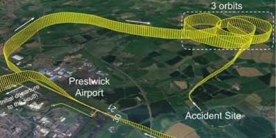
The pilot was alone on board. The aircraft departed in visual meteorological conditions (VMC) and initially climbed to 14,000ft above sea level (asl) before climbing to and maintaining 15,000ft. The pilot then requested a minor deviation from the route of flight to avoid entering clouds. However, during this deviation the clouds could not be avoided and the aircraft entered instrument meteorological conditions (IMC). Shortly thereafter, the aircraft’s attitude direction indicator displayed the ‘AHRS ALIGN’ (attitude and heading reference system alignment) message and indications of attitude (pitch and bank) were lost while indications of airspeed, altitude and vertical speed were retained.
At the same time the aircraft’s horizontal situation indicator also indicated a failure, displaying a red X over the HDG (heading) annunciation. While the aircraft was still flying in IMC its altitude began to fluctuate. It then began an unintentional left turn, eventually turning approximately 90° to the left of the assigned track. The pilot requested a return to the Calgary, Alberta, area and declared an emergency, reporting the loss of attitude and heading information from the aircraft’s instruments.
ATC provided the pilot with a heading that would turn the aircraft toward Calgary. During this turn the pilot experienced spatial disorientation, the aircraft’s bank angle progressively increased and the aircraft began to descend. Over the next five minutes control of the aircraft was lost multiple times. The aircraft entered a series of spiral dives, abrupt climbs and at least two aerodynamic stalls.
Flight data recovered from the ADI and HSI indicate that during these manoeuvres the aircraft’s climb rate increased to as much as 8,500fpm, and its descent rate increased to as much as 23,000fpm. In addition, the aircraft’s indicated airspeed varied from a low of 43kt to a high of 242kt, exceeding the aircraft’s never exceed speed by approximately 70kt. The aircraft descended to as low as 8,100ft asl (approximately 700ft agl) before abruptly climbing again.
The pilot could see the terrain below as the aircraft descended through approx 8,500ft asl and control of the aircraft was regained at approximately 8,100ft asl. At the time, the aircraft was in the Kananaskis Valley where nearby mountain peaks extended up to 10,364ft asl. The pilot maintained a height ranging from approximately 700 to 1,000ft agl and followed a road out of the Kananaskis Valley.
The occurrence pilot entered the avionics defect in the aircraft’s journey log and one day after the occurrence the aircraft owner (who was not the occurrence pilot) flew the aircraft to Alberta, to address the defect. Contrary to the regulations, no entry was made by the occurrence pilot in the aircraft’s journey log or technical record about having exceeded the aircraft limits. The aircraft continued to be flown for an additional 12.3 hours after the occurrence flight until the flight data retrieved from the Garmin GI 275 multi-function instruments revealed the breach of aircraft limits. At that time, the aircraft owner also noted fuel weeping from around rivets in several locations and that the landing gear no longer fully retracted.
Accident 3
The pilot of a PA 24-180 was conducting a VFR cross-country flight. He filed a flight plan before departure but declined a formal weather briefing. Although the weather information he gathered about the flight could not be determined, he told his wife before departure that the weather at his intended fuel stop was ‘not good’, but that he had sufficient fuel onboard to continue to the destination airport without refuelling..
GPS data showed that the aeroplane proceeded directly toward the airport where he intended to refuel, and while approaching the airport for landing the pilot reported via radio that he was ‘hung up’ and would manoeuvre for a left downwind. There were no further radio comms from the pilot. GPS data revealed that, about the time the pilot made the final radio call, the aeroplane was about 500ft agl. It then banked left and rapidly descended into rising terrain. The wreckage was located on a hillside about 4nm south-east of the airport.
Although the pilot held an instrument rating, his instrument currency could not be determined, and his wife, who flew with him often, stated that he rarely filed or flew IFR flights. Weather camera images revealed the low cloud layers and limited visibility in the area of the accident site around the time of the accident. Despite his apparent awareness of forecast marginal VFR conditions and temporary IFR conditions, the pilot chose to depart and continue into an area of low cloud ceilings and rising terrain.