A new technology that could do away with the need for Temporary Danger Areas (TDA) for drone operations will be tested in September.
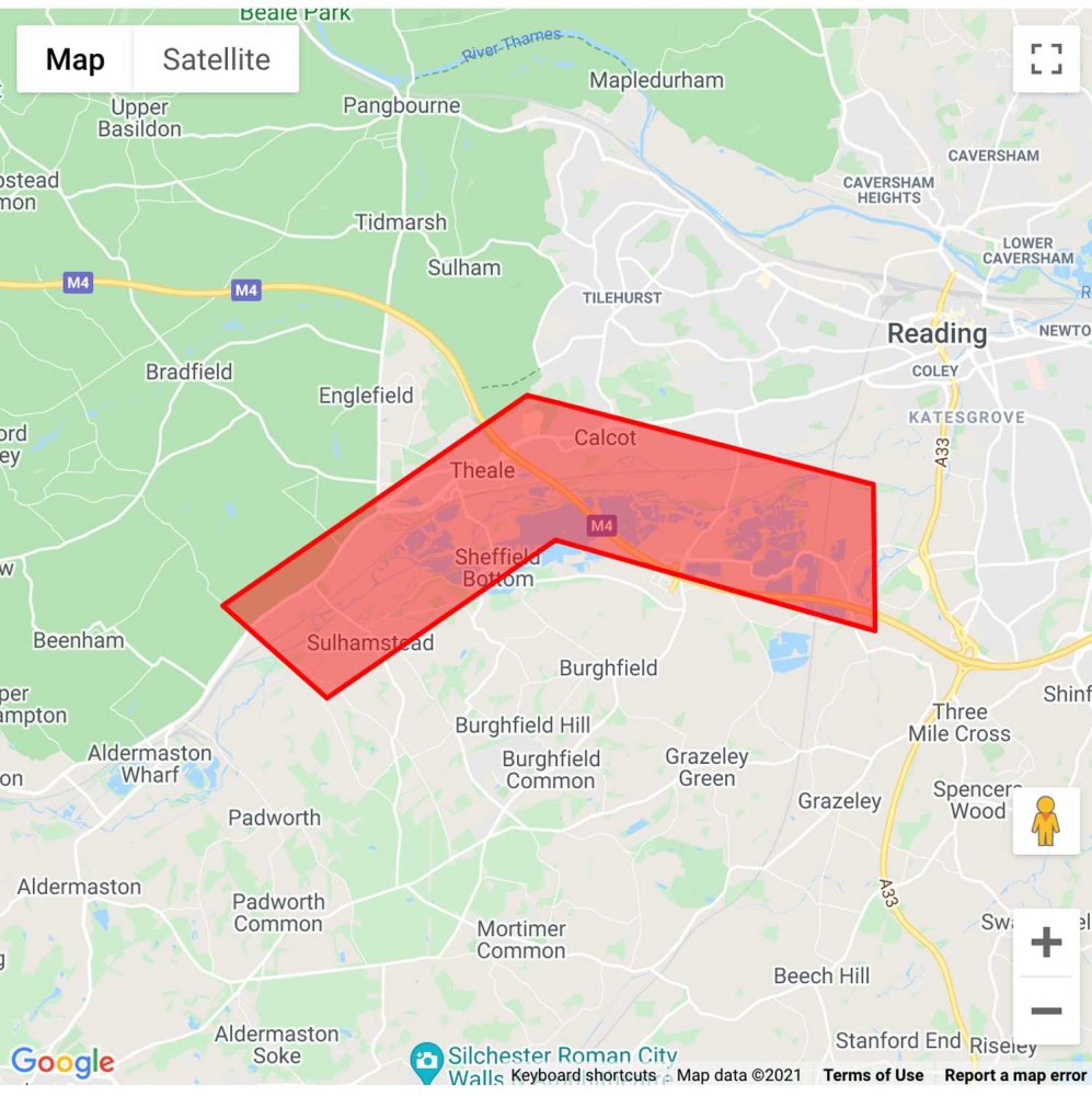
A Berkshire based company called Altitude Angel has put in for a TDA south of Reading to test ground-based Detect And Avoid (DAA) technology that the company calls Arrow.
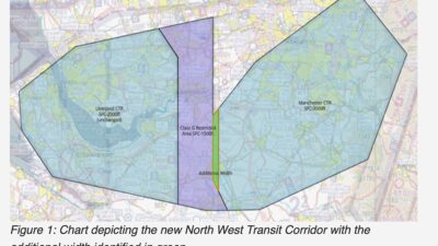
The TDA is decribed in Temporary Airspace Change Proposal ACP-2021-032. It is 8km long, 120 metres wide and has a top height of 600ft agl.
“Drones flying within the Arrow Drone Zone will be tracked and monitored via Altitude Angel’s UTM (unified traffic management) platform, GuardianUTM O/S, which communicates with ground and aerial infrastructure,” says the ACP.
“In doing so, it provides automated navigation assistance for drones flying within the Zone, pre-flight authorisations, and automatic separation assurance.
“Nearby manned aviation and other non-participating drones will be mapped in real-time so safe distances are maintained, and appropriate avoidance actions can be taken if they are predicted to be breached.
“If a future conflict is predicted, drones involved will be automatically given appropriate avoidance instructions, such as instructions to change flight path, hold, return or land. A remote pilot will also be alerted, and manual control of the drone can be taken at any time.
“Once the technology has been successfully demonstrated, we believe we can do away with the need for ACPs to be requested where our platform is utilised, therefore allowing both drones and manned aviation to share the same sky, safely.”
One of the stakeholders involved in the consultation said, “The low top level of the TDA (c.600ft agl) should not create a significant impediment to fair weather operations.
“However the ACP does not appear to recognise the role of the M4 as a visual navigation feature for VFR traffic, nor cognisance of the SW entry route to White Waltham. There are also no attempts to mitigate the timings of use of the TDA when the UAS is not being used.”
ACP-2021-032 Consultation
ATC for drones
In other drone news, Air Traffic Control in The Netherlands (LVNL has conducted a successful trial during which air traffic control instructions were issued to a drone pilot via the Altitude Angel developed GoDrone app.
The test took place in the controlled airspace around Rotterdam – The Hague Airport, and were supervised by the control tower.


6 comments
Looking through the proposal it looks a very lightweight document (again) with little detail to help us. I see the sponsor wants to see how their systems work in a live environment , but with little idea of what that means. There is a sort of a mention that manned aircraft might use a crossing service – that will work, I don’t think.
Now all we need is to respond to the detailed consultation, they don’t want to do.
Dear Peter,
Many thanks for the above comment.
We have been working with the CAA Innovation Sandbox for over two years as we build and demonstrate our solution which will enable and support an integrated sky.
We have actively run trial programmes with SESAR in live environments and have deployed our platforms with ANSPs in mainland Europe. Furthermore, UK airports have also implemented our integrated solutions.
As a business, we understand there are challenges around EC and its adoption on both sides. Personally, I don’t believe EC is the solution which will fix everything and think things can be done differently.
To be clear, the system is being deployed now will be monitoring the traffic in the area for approximately two months while we can gather a baseline of evidence. There will also be a build-up of activity and testing under Visual Line Of Site rules before we proceed to BVLOS in the proposed TDA.
Whilst we cannot provide all of the details of our operation, I would like to reassure you safety is primary concern and no operation or flight will be undertaken if it is not safe to do so.
I appreciate your comments and the time you have taken to post them
If you have any further concerns or comments could I ask you send them to [email protected]
Kindest regards,
David
This would appear to be a test of an autonomous Detect and Avoid system based on visual technology, which is what is really needed for BVLOS drone operations and should be the final solution to remove any need for segregated airspace. That is mentioned in some of the documents but seems to get lost in others. This is a much preferred solution, much better than the other proposals such as the “pay to enter” class L airspace proposal which would mean airspace is only available to airspace users who have purchased some kind of equipment.
Some of the proposal documents suggest requiring a TDA upto 1000ft AGL which would be unacceptable, others sugggest 600ft, more acceptable, but this needs to have weather minima, such as if the cloud base is below 1000ft, the TDA reverts to class G.
I really think this should first be being tested in a dedicated UAV area such as Salisbury plane or Aberporth, then once the visual detection system is proven, this sort of trial could take place- unless they have already done that.
Seems a lot better proposal than most of the others and actually has a positive end result.
Dear Nigel,
Thank you for the comments and we appreciate your support.
For the UK to move forward and break away from the segregated airspace approach, we believe there is a solution which can be deployed utilsing our Unified Traffic Management platform.
This platform is what underpins the DAA solution. Also, unlike other DAA solutions for BVLOS, ours works on a one- to-many ratio, where as other solutions work in a silo/1-2-1 basis.
We will be able to detect EC and NON-EC equipped aircraft in the area. We’ll be conducting two months worth of trials before moving into the TDA environment. We have kept the TDA as tight as possible with the buffer zones, so our solution can be tested to detect beyond those buffers.
FYI – we have run trials with equipment (prior to COVID lockdown) at a small airport to test the detection capabilities which were successfully. Further testing has been done during lockdown, albeit limited due to travel restrictions etc. Other aspects of the solution have also been utilised and demonstrated over the past 18 months including drone delivery services in the UK and mainland Europe.
We hope, under the DfT Future Flight Challenge initiative, we can test and demonstrate this capability in a live environment with real-world use cases. In doing so, we will be showing the world how the UK can lead on what the future airspace management can look like.
You mention the cloud base and weather minima. We have a set of criteria we have to fulfil for operations to take place. The cloud base ceiling @1000ft is a valid point of consideration and it’s something we are looking at. You’re not the first to raise it and I thank you for doing so.
If you have any further concerns or comments could I ask you drop me an email at [email protected]
Kindest regards,
David
This is pretty congested airspace (I live right here) What happens in an emergency? What if a drone goes AWOL and pops out of it’s area? It will end up right slap bang in the middle of some seriously busy sky. What mandatory systems for inspections/standards of Maintainance and even of build are in place? What fail safes? A TDA doesn’t solve that – proper oversight does. Not seeing that. I contacted the company to ask this but complete silence was the answer … if transparency could be offered we could possibly get on with developing a system for sharing the sky safely but cloak and dagger secrecy and refusal to answer safety question on grounds of commercial sensitivity is not acceptable. We have reasonable grounds (like wanting to stay alive) to know about the stuff being put into the airspace we’re using.
Dear Cath,
Many thanks for the comment above.
I have checked with the wider team at Altitude Angel and we cannot find any emails or communications being made by yourself to us with regards to your concerns, but I am happy to address those made above. Should you have any other questions or queries then please feel free to email us at [email protected]
I am the Project Lead and the person who has been working with the regulator for the last two years on the Arrow Drone Zone project.
As a professional, I have over ten years’ experience working with the regulator, which has involved writing numerous safety proposals for unmanned operations to ensure proper oversight is being conducted and recorded. Some of which have involved simultaneous manned and unmanned operations.
In addition, Altitude Angel is the only organisation in the world to have safety integrated drones into congested areas and airports. We have a highly experienced team, many of whom have a background or significant experience in manned aviation, included a former RAF ATC.
To address your points; the systems being used are proven and already operate under Operational Authorisations by the UK CAA. The systems have redundant failovers to reduce failures in flight. In line with EASA operating principles, we have contingency and emergency flight volumes configured.
For further information I would recommend you visit the ACP Portal where we have posted a presentation which goes in to greater detail. We are, and will continue to be, as open and as transparent as commercially possible with the GA community.
We have on many, many occasions, spoken of our wish and desire to implement an eco-system which is integrates all airspace users safely and securely, and not a segregated solution, which is why we work with the GA community and partners to actively share flight plans and provide services, and hope to expand on this during the testing of our DAA solution.
Kind Regards,
David Walters
Altitude Angel
Project Arrow Lead