It’ll come as no surprise that the UK does Danger Areas and other Special User Airspace in ways that are different to other countries, here’s a refresher and update… About a year ago we covered some of the lesser known airspace features that you might encounter in the VFR environment; including laser sites, glider sites and aerodromes with ‘unusual activities’. Most of these are not barriers to flight, but may require some knowledge and planning to navigate safely.
Danger, restricted and prohibited areas raise similar questions – there is sometimes confusion around their status and the extent to which they must be avoided. Let’s start with definitions from the UK Standardised Rules of the Air:
- Danger area means an airspace of defined dimensions within which activities dangerous to the flight of aircraft may exist at specified times
- Restricted area means an airspace of defined dimensions, above the land areas or territorial waters of a State, within which the fight of aircraft is restricted in accordance with certain specified conditions, and
- Prohibited area means an airspace of defined dimensions, above the land areas or territorial waters of a State, within which the flight of aircraft is prohibited.
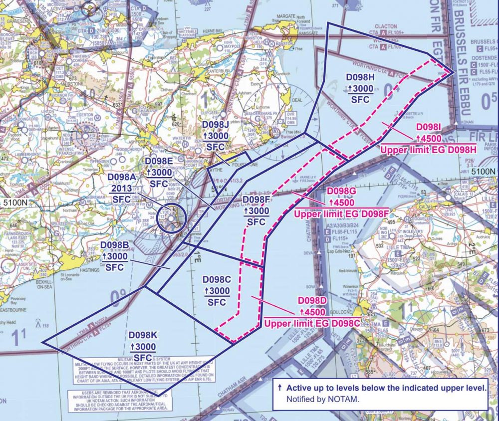
Information regarding individual areas is available on the CAA VFR chart, moving map devices and in ENR 5.1 of the UK Aeronautical Information Publication (AIP).
Prohibited areas
Prohibited area is self-explanatory, although note the altitude to which the prohibition applies. This will be listed on the chart or moving map device as an ‘above mean sea level’ (AMSL) figure. The UK has very few prohibited areas, in contrast to France, where a significant number are established over nuclear power stations and other sensitive areas.
Restricted areas
Most restricted areas in the UK are quite small and extend to several thousand feet AMSL. If one is on your route, check the altitude and types of aircraft to which it applies. The VFR chart legend will normally provide more detail, with AIP ENR 5.1 containing the full chapter and verse.
There is also the ‘restricted area (temporary)’ – RA(T). Such designations are set up for short-term restrictions such as airshows or other large public events. These will be in Notams and have an associated Aeronautical Information Circular (AIC), containing full details of the restrictions.
Danger areas
Danger areas are more widespread than restricted or prohibited areas and tend to be larger. There are normally options to cross them, including a danger area crossing service (DACS) or recorded activity information lines – again these are on the legend of the VFR chart.
London or Scottish Information may also have activity details. As with restricted areas, ENR 5.1 of the AIP lists each danger area in the UK and all associated information.
It is sometimes pointed out that flying through danger areas is not prohibited, unless subject to military byelaws. While this is true, entry into a danger area is not advisable – other than the obvious danger to you and the aircraft, if there is activity ongoing, the relevant authority may file an occurrence report, on the basis that entry posed a risk to aviation safety.
Some danger areas are activated by Notam, and these will have a broken border on the chart rather than a solid one. A thorough check of Notams will ensure that you are aware of any activated areas, and as with permanent ones, there may be more tactical information available by radio or telephone.
The CAA recently published a Supplementary Instruction to CAP 413: Radiotelephony manual, which from April introduces some minor changes to terminology for danger area crossing and information services.
Flying abroad
Some areas of France can look a bit daunting in terms of restrictions, but often these can be navigated with pre-flight planning and help from ATC.
France has excellent regionalised flight information services, which will often know the status of restricted or danger areas on your route.
Occasionally French ATC can come over as a bit informal when dealing with VFR traffic so, if in doubt about clearances or the status of area, be assertive and probe further.
The only completely ‘no-go’ spots are the prohibited areas – heavy fines for infringement may be applied, and they often extend to quite high altitudes.
The French have a formal network for military low flying, known as the réseau très basse altitude (RTBA), essentially the ‘low altitude network’. This consists of a series of restricted and danger areas, information on which can be found on the activation of low altitude areas (AZBA) page of the French aeronautical information service website (SIA).
Like the UK, most states will publish details of prohibited, restricted and danger areas in the ENR section of the AIP. VFR charts and moving map devices will normally contain the relevant information as well, but sometimes it is best to check for more detail.