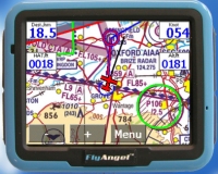
<a href=’http://www.flymap.co.uk’ target=’_blank’>Flymap UK</a>, the suppliers of the <a href=”newsfeed.php?artnum=382″>Flymap Moving Map system</a>, has teamed up with Road Angel to produce a new product that gives moving map information for both air and road use.
The new product, called FlyAngel, will include all the features of Flymap but will also add a range of features for use on the road, including blackspot and camera alert system, post code search facility, advisory speed limit at a hazard and street level mapping in the UK with major route mapping for major routes. There’s also an MP3 player.
Of course, the big advantage is that you can use the same system to get you to the airport, and then to get you from the airport to where you’re going. The Flymap system incorporates CAA 1:500,000 scale maps and, in its professional version, the Pooley’s Flight Guide.
The FlyAngel is expected to be launced later this week at Aeroexpo at Wycombe Air Park. It will cost £650 for the basic version and £800 for the FlyAngel Professional.