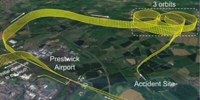
The Air Traffic Controller observed a 7000 squawk on radar enter the southern part of the Stansted CTA near Epping indicating 2,200ft. As the aircraft entered the CTA the Controlled Airspace Infringement Tool (CAIT) triggered an alert.
The aircraft was seen to track north-west and then west, before leaving controlled airspace to the west of North Weald. The aircraft was then seen to squawk 5024 (Farnborough LARS North) and the pilot obtained a Basic Service.
This incident took place when there had been a large decrease in the amount of Commercial Air Transport traffic operating at Stansted Airport during the pandemic, and consequently there was no impact on the operation at Stansted.
However, as traffic levels start to increase at airports a similar infringement would likely result in disruption to arrivals or departures.
The pilot’s story
The pilot reported that they had planned to fly a return flight from Stapleford to practice navigation using VFR chart and dead reckoning, ahead of a future training course. The route had been planned with turning points at Cheshunt / Top Farm airstrip / Bassingbourn, disused / Barkway VOR (BKY) / Panshanger, disused.
The route had been chosen as they were points of interest for a future CPL course. The flight was also to take a passenger flying who had never been in a light aircraft before. The passenger had a history of motion sickness experienced in other forms of transport.
On lining up on the runway the pilot carried out a check of the Direction Indicator but failed to correct a 5° error.
The route planned started with an overhead departure from Stapleford.
After departure from Runway 21L, the pilot followed the left-hand circuit and established a climb on the downwind leg. Shortly after turning downwind, the aircraft ahead in the circuit reported that they were returning to Stapleford for an immediate landing due to a low oil pressure indication.
At the time there was an aircraft already on final and another aircraft late downwind nearing the base leg turn making a total of four in the circuit.
The pilot of the subject aircraft decided the safest course of action was to continue climbing on the downwind leg and delay the turn overhead onto the planned heading of 290° for Cheshunt, and be at or above 1,800ft when crossing the final approach path.
This resulted in the turn onto the planned heading occurring approximately 1nm further north-east than planned. The turn itself was a gentle turn with 10° angle of bank, due to turning in the climb.
The result of the two actions led to a track error of 0.6nm, with the actual track offset to the north-east, towards controlled airspace.
At the top of the climb, the pilot completed the after take-off checks. These included a gross error check of the route and heading, where the pilot noted that ground features were seen as expected.
During the checks the pilot noted that the passenger had been unusually silent since take-off. The pilot became concerned about their wellbeing and questioned how they were feeling, to assess if an immediate return to Stapleford would be required.
The distraction led the pilot into failing to note and correct the offset actual track, caused by the late turn, and failing to correct the error in the DI. The pilot also recalls the wind appeared stronger than had been forecast, leading to a further 10° track error.
Due to these errors, the pilot inadvertently entered CTA-2 one minute after the top of climb, south of VRP Epping.
After checking if the passenger was OK, the pilot noticed that the picture, particularly the aircraft’s position relative to North Weald, didn’t look correct. The pilot referred to his VFR moving map, which was under the plog, and noticed that they had infringed the Stansted CTA.
As the aircraft was now close to the south-eastern boundary of the CTA, the pilot turned the aircraft onto a heading of 225°M to leave the CTA as quickly as possible, while at the same time commencing a descent to increase ground speed and expedite the exit of controlled airspace.
Throughout the initial phase of flight, the pilot was communicating with Stapleford Radio due to still being in its ATZ.
Findings and causal/human factors
The pilot carried out a detailed post-flight analysis to the CAA as part of its MOR submission, by reviewing the events leading up to the occurrence in terms of Threat and Error Management.
In it they commented that they were previously unaware of the Take 2 guidance and noted that their initial planned track was close to the CTA and ‘did not allow enough margin for error’. The track planned for this flight was within 1nm of Stansted’s CTA 2.
It would have been beneficial to have a more prominent landmark for the first turning point that would have made visual navigation easier.
A less complex departure from Runway 21 could have been to climb straight ahead, considering noise abatement, and then turn to the River Lea reservoirs, this would allow a greater margin from controlled airspace in addition to using a more visible reference.
The pilot also reflected on how they now consider that there were too many aims and objectives for this flight, which unnecessarily increased their workload. Reflecting on the event, the aims of this flight could have been covered across two or three flights.
Flying with passengers always introduces the threat of distraction and increased workload. This is heightened with one that has the potential to be unwell.
In such circumstances, a simple route planned to minimise proximity to controlled airspace might give the pilot more capacity to provide reassurance and explanation of what is taking place during the flight, and possibly result in a more enjoyable flight for the passenger.
Although current, the pilot also believed that skill-fade, and therefore reduced capacity, caused by the lockdowns and effect of the pandemic, also was a contributory factor in this incident. Throughout the pandemic, most of their flying was focused on practising visual circuits.
The pilot, on reflection, added that the first time practising the use of navigation using dead reckoning than a VFR moving map, after the most recent lockdowns, could have been conducted with a qualified instructor or fellow PPL pilot in the right-hand seat, rather than with a non-pilot passenger.
An element of complacency may also have been evident. The circuit for Runway 21LH was the one most flown by the pilot, and therefore the one with which they were most familiar with.
However, due to a recent change to widen the Runway 03 downwind leg further to the north-west, the pilot has recently flown that as part of a ‘club check flight’.
Having not flown much due to covid-related restrictions, this recent flight led to the ‘familiar’ picture developing when in proximity of the M25/M11 motorway junction, along with a false sense of margin from the CTA when conducting the gross error check at top of climb and in the vicinity of that reference point.
All the pilot’s formal training was to east or south of Stapleford, most noticeably over Kent and Essex, and most of the cross-country flying done since obtaining a licence, the pilot had been accompanied by a qualified pilot. The pilot felt when flying to a new area it could have been advantageous to be accompanied by a fellow PPL pilot familiar with the points of interest and route.
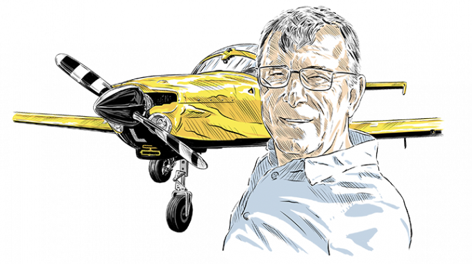
Nick’s analysis
Once again, a combination of events led to an incident. In this case a pilot was faced with a number of issues and distractions which resulted in an incursion into Stansted airspace.
Fortunately there was little commercial traffic and the pilot spotted the mistake early, and quickly corrected the error. The pilot offered a very open and honest debrief on his actions.
UK airspace is complicated and very cluttered, especially in the south of England. Many pilots unfamiliar with southern England shy away from what they see as ‘shark-infested’ territory.
There is certainly little scope for error and the days of a quick call to ATC afterwards to apologise for an incursion seem to be over. However, there are various ways to make flying in this airspace quite feasible.
Planning is the key. Understanding the location of controlled airspace for your route – both laterally and vertically – is vital. Much of the London TMA has a base of 2,500ft that crams GA aircraft within a tight envelope of airspace.
The ‘Take 2’ initiative recommends a buffer of two miles laterally or 200ft vertically from controlled airspace (CAS).
I agree with the two miles buffer as a minimum, but would argue that 200ft vertically is far too close for comfort.
Errors in altimeter settings, distraction, or just poor flying accuracy could easily result in an inadvertent entry into CAS. I would always aim for a 500ft vertical margin where possible.
As the report indicates, flying close to CAS is a really good time to be making sensible use of a moving map device. However, these devices have a habit of sucking pilots’ eyes onto them for long periods, leading to weaker lookout.
I find that my iPhone map is quite sufficient for navigation, preferring it to a larger tablet device, which can clutter a cockpit already festooned with paper charts and kneepads. Occasional glances at the phone display are enough to maintain my picture of planned track against actual track.
In the above event the pilot got a bit overloaded with a sequence of events while positioning in the airfield circuit to depart on the navex.
I am a big fan of using so-called remote starting points for navigation exercises, as the report alludes to. A large familiar feature a short distance away from the airfield allows pilots to put the busy and distracting period of airfield departure behind them, allowing a calmer and more orderly start to the navigation. Just like good approaches lead to good landings, I find that a good start to a navex usually leads to a decent trip.
Finally, and considering the above point regarding remote starting points, as part of the planning process don’t forget to ‘join the dots’ of your beautifully crafted navigation route to the airfield departure and arrival.
I find many pilots make a mess of the beginning and/or the end of navexes by not thinking through the expected departure and arrival, and any possible contingencies such as runway changes. These are all much easier to think about before you get to the aircraft and might avoid joining for the wrong runway at your destination airport!
Four key points
- Plan routes carefully especially if they are near to or under controlled airspace.
- Use remote starting and/or end points to avoid distraction at busy times.
- Use ‘Take 2’ but consider more vertical spacing from controlled airspace.
- Use a moving map display to assist with navigation, but don’t let it drag your eyes away from looking out.