How do you find out what an airfield is like to fly to when it’s halfway across Europe? Yes, you can Google it and see what comes up but one member of the International Aircraft Owners and Pilot Association (IAOPA) is taking things a step further.
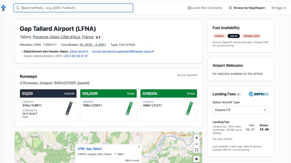
Thomas Witt, a member of AOPA Germany, has created Airfield Directory, a free, open and non-commercial resource built around pilot-contributed reports.
Its aim is simple but ambitious: to make essential flight planning intelligence — often scattered, outdated, or locked behind paywalls — easily accessible, reusable, and openly available to the European GA community.
Launched only months ago, the platform has gained significant traction. In just four months, more than 540 pilot-written airfield reports (PIREPs) have been submitted, covering destinations across Europe. Contributions have come from pilots operating in the UK, France, the Netherlands, and a growing list of other countries.
The directory aggregates practical data that pilots frequently struggle to verify through official publications alone. These include landing fees, fuel availability, fuel prices, and local operational notes such as runway conditions, noise abatement procedures, and ground handling tips. The emphasis is on real-world experience from active users rather than purely administrative data.
A distinguishing feature of the project is its multilingual accessibility. All submitted content is automatically translated into six languages — German, English, Spanish, French, Italian, and Dutch — enabling cross-border usability and reducing language barriers that can complicate European flying.
The project operates under an open Creative Commons licence, similar to Wikipedia. “This approach encourages reuse and sharing of the data within the aviation ecosystem, potentially supporting developers, flight planning tools, and other community resources,” said IAOPA.
Airfield Directory